
Advanced Hydrology and Hydraulics CE for Engineers

For engineers considering advanced hydrology and hydraulics planning CE, the Hydrology and Hydraulics On-Demand Webinar Package runs 5 hours and awards 0.5 CEUs. One CEU converts to 10 professional development hours (PDHs), and CEUs and certificates are earned course by course. The package covers 11 modules on flood hydraulics and related topics.
Choosing advanced hydrology and hydraulics planning CE for engineers involves more than finding a topic relevant to your work. Check how the course awards credit and whether its format and length fit your schedule. Those details help you assess the course before enrolling.
Here, you’ll find an overview of the flow and floodplain topics, how the CEUs relate to PDHs, and what the 5-hour course covers. You’ll also learn how self-paced, online continuing education from Education Pathways can support your professional learning.
Key Takeaways
- See how channel, orifice, weir, and pipe flow topics relate to practical hydraulic analysis.
- Learn what floodplain mapping and inundation analysis add to hydrology-focused continuing education.
- Understand how course-by-course credit and certificates work across the package.
- Use the package’s stated duration to decide whether its format fits your schedule.
- Explore how self-paced, online architect and engineer continuing education can support your learning goals.
Channel, orifice, weir, and pipe flow
Useful preparation includes reading watershed maps and understanding basic hydraulic terms. Familiarity with GIS, particularly ArcGIS Pro, can help you follow watershed-tool demonstrations. Pay attention to how the inputs affect the outputs.
Open-Channel Flow Topics
Open-channel analysis examines water moving through a channel with a free surface. For example, engineers may study runoff entering a roadside ditch after rainfall. They consider the channel’s shape, slope, and flow conditions to understand how water moves downstream. Look for material that connects watershed runoff to channel behavior instead of treating channel flow as an isolated calculation.
Hydrology provides the flow estimate that hydraulic analysis then applies to a channel or structure. NRCS hydrology modules 101-106 appear in an introductory hydrology video. EFH-2 implements procedures from Chapter 2 of the NRCS Engineering Field Handbook, NEH 650. These topics help connect watershed characteristics and rainfall inputs with runoff and peak discharge estimates.
That connection matters when tracing water from a watershed into a conveyance. For example, a peak discharge estimate can inform analysis of flow through a channel reach. The EFH-2 procedures estimate runoff and peak discharge using watershed characteristics and rainfall amount and distribution. Pay attention to how those inputs affect the estimate, then how the resulting flow informs hydraulic analysis.
Orifice and Weir Flow
Orifices and weirs control or measure water in different ways: an orifice directs flow through an opening, while a weir lets water pass over a barrier. A culvert opening illustrates flow through an opening; a weir demonstrates flow over a crest. Identify the flow path and the geometry that controls it to understand the distinct hydraulic questions each structure raises.
Compare the structures by tracing water across the control point. An orifice directs flow through an opening; a weir allows flow over a crest. These differences shape how engineers frame a hydraulic analysis. When reviewing course material, note the geometry and flow conditions in each example. This makes it easier to connect the concepts with drainage structures encountered in design work.
Pipe hydraulics extends the same practical focus to enclosed conveyance. The NRCS Oklahoma State Engineer pipe hydraulics video has a runtime of 15:55 and a suggested viewing time of 10:20. Use the viewing time to plan a focused study session, then review the full runtime if you need the complete presentation. Track how the example frames pipe flow and connects it to hydraulic decision-making.
For culvert applications, the HY-8 culvert design tech talk replay took place on February 27, 2023. Consider how pipe and culvert examples relate to the upstream and downstream flow conditions. Channel, orifice, weir, and pipe concepts work together when water moves through connected drainage features. Following that route helps organize the analysis, from an open channel to a structure and back.
Floodplain mapping and inundation analysis
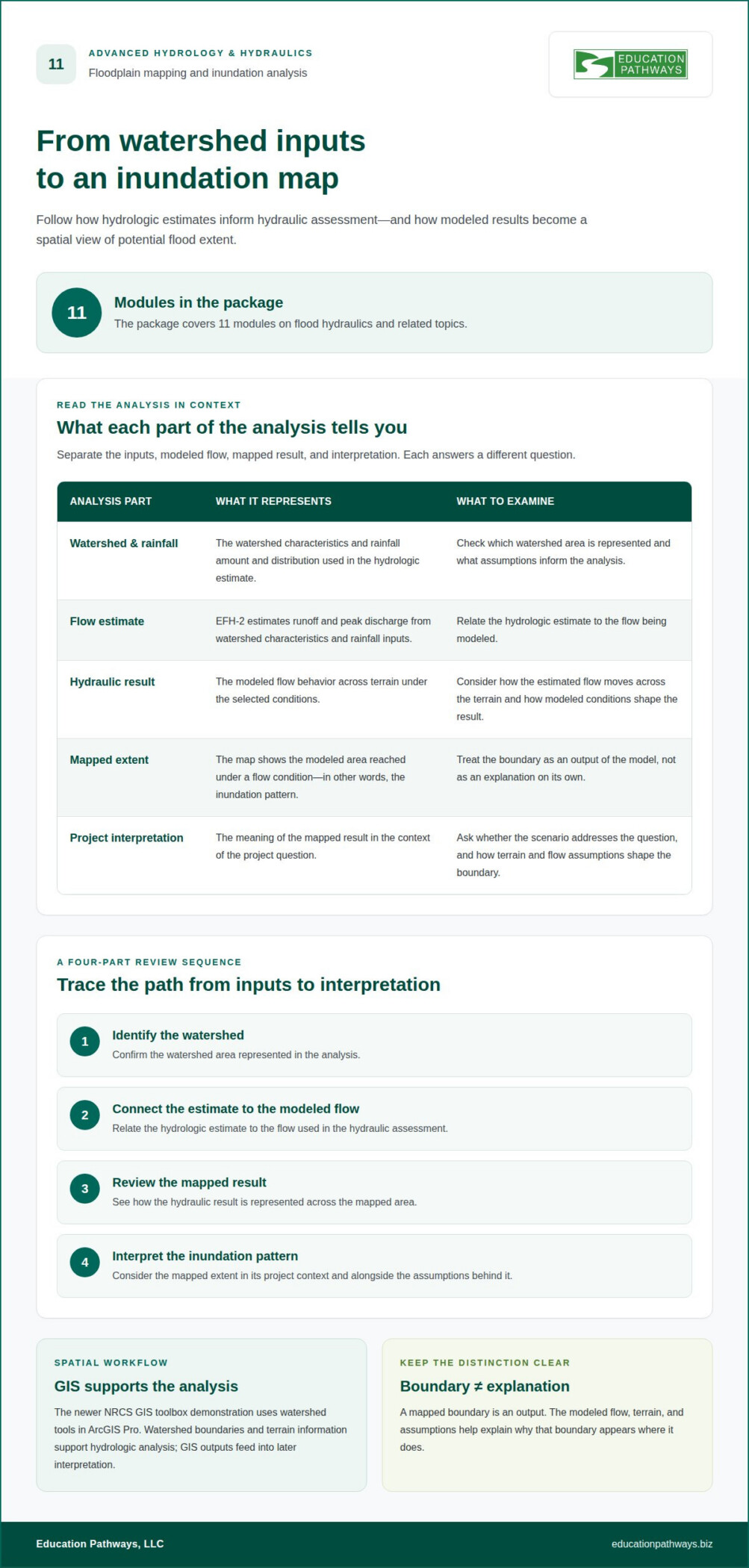
Floodplain mapping turns hydraulic results into a spatial view of where water may spread. Inundation analysis focuses on the area reached under a modeled flow condition. The course package includes 11 modules on flood hydraulics and related topics. These subjects help engineers connect flow behavior with areas exposed to flooding, rather than viewing a discharge value alone.
To interpret a flood map, trace the model inputs through to the mapped result. Start with the watershed and rainfall assumptions, then consider the estimated flow and how it moves across the terrain. The map shows the modeled extent, but it does not explain the assumptions behind it. For example, changing the modeled flow can alter which parts of a low-lying area appear inundated.
Floodplain analysis also benefits from clear spatial data. The newer NRCS GIS toolbox demonstration uses watershed tools in ArcGIS Pro, and that toolbox version was released in early 2026. The example points to a practical skill: understanding how watershed boundaries and terrain information support hydrologic analysis. Engineers reviewing this material should note how GIS outputs feed into later interpretation, not just how to operate a tool.
For a focused review, trace the analysis in sequence:
- Identify the watershed area represented in the analysis.
- Relate the hydrologic estimate to the flow being modeled.
- Review how the hydraulic result is represented across the mapped area.
- Interpret the resulting inundation pattern in its project context.
This sequence helps separate hydrologic inputs from hydraulic results and map interpretation. EFH-2 estimates runoff and peak discharge using watershed characteristics and rainfall amount and distribution. Those estimates can inform the flow used in a hydraulic assessment. The resulting spatial view helps communicate where modeled water may extend, while the underlying assumptions explain why that boundary appears there.
When reviewing a floodplain map, consider how the mapped boundary relates to the modeled conditions. The boundary is an output, not an explanation on its own. Ask whether the scenario addresses the question being assessed, and examine how terrain and flow assumptions shape the result. This approach helps engineers discuss flood exposure without treating a visual boundary as independent of its inputs.
The 11-module flood hydraulics curriculum gives learners room to connect mapping with related analysis topics. ArcGIS Pro watershed tools provide a concrete example of the spatial workflow. Together, these topics help engineers follow the path from watershed information to flow estimates, then to an inundation view that can support project discussions and planning decisions.
Continuing education units
Credit depends on the course format and the credential you hold. The package awards CEUs by course, and approval details differ between live and on-demand options.
Continuing Education Unit Details
The complete webinar package awards 0.5 continuing education units. One CEU converts to 10 professional development hours (PDHs). CEUs are earned, and certificates are issued, for each course separately. That means the package total is not one single course record. Review the credit assigned to each course and keep its certificate with your continuing education records.
The live webinar has a separate credit structure. It is designed to qualify professional engineers for 6.0 PDHs. It is also approved for 6.0 HSW PDHs through the Landscape Architecture Continuing Education System. The American Institute of Architects Continuing Education System approves it for 6.0 HSW LUs. These are distinct credit labels, so identify the unit type that applies to your license.
PE Credit Acceptance
State engineering boards do not automatically accept every course for PE credit. The on-demand course is not pre-approved by licensing boards and may not qualify for the same credits as the live presentation. The live webinar’s design for 6.0 PDHs and approvals through professional education systems do not, by themselves, establish acceptance by every state board.
For the live webinar, an attendance certificate requires participation in the entire session and a score of at least 80% on the post-course quiz. Treat that completion condition separately from board acceptance. A certificate documents course completion; the licensing board’s rules determine whether that course applies to a PE renewal.
State-Specific CE Requirements
Water resources engineers must follow the PE continuing education rules of each state where they hold a license. This course information does not establish a single nationwide credit requirement. Requirements may vary by licensing jurisdiction, renewal cycle, and recognized credit types. Consider the course topic and format when determining whether it fits a license’s requirements.
Use a practical sequence: identify the state license, determine the applicable renewal period, then match the course’s credit type and documentation to that state’s rules. For example, distinguish the package’s 0.5 CEUs from the live webinar’s 6.0 PDHs. Keep the course certificate and completion record together. This makes the credit type clear when organizing records for a specific jurisdiction.
Course package length
Course length varies by format: the on-demand package totals 5 hours, while Flood Hydraulics training lasts 5 days. U.S. engineers can find advanced hydrology and hydraulics planning CE for engineers through universities, professional organizations, and specialist education providers. Compare the curriculum, delivery format, and credit details before choosing a course.
The Hydrology and Hydraulics On-Demand Webinar Package is 5 hours long. Its on-demand format lets learners work through the material outside a scheduled live session. A separate live Hydrology and Hydraulics for Municipal Stormwater Engineering webinar was scheduled for May 9, 2024, from 9:00 am to 4:30 pm CDT. That listed session date has passed, so distinguish it from on-demand course material.
Flood Hydraulics training lasts 5 days. That duration differs from the 5-hour webinar package, so compare the course’s actual scope and delivery before treating them as equivalent options. The available course facts identify the webinar package as on-demand and the municipal stormwater webinar as live. They do not establish that the 5-day training is online or in person.
Curriculum, format, and accreditation answer different questions. The curriculum shows which hydrology or hydraulics concepts the course addresses. Format tells you whether learning is scheduled live, on demand, or delivered through training sessions. Credit information identifies the units or professional development hours associated with completion. For example, a 5-hour course duration does not itself tell you how many credits a board will accept.
For PE credit, the format and approval details matter. The on-demand course is not pre-approved by licensing boards and may not qualify for the same credits as the live presentation. The live webinar was designed to qualify professional engineers for 6.0 PDHs. Its live attendance certificate requires attending the full webinar and scoring at least 80% on the post-course quiz.
Non-accredited or out-of-state CE may not match a state’s licensing requirements. A certificate documents course completion, but it does not establish that every board accepts the credit. Acceptance depends on factors such as approval status, credit type, delivery format, and the rules for the state where the license is held. For example, the on-demand option is not pre-approved by a board, unlike the live webinar.
Use a simple comparison before enrolling: note the course duration, delivery method, subject matter, and stated credit. Then relate those details to the license and jurisdiction. A 5-hour on-demand package, a scheduled live webinar, and 5-day Flood Hydraulics training represent different time commitments. Matching the format to your schedule is useful, but matching credit details to your PE renewal needs is essential.
A complete-package purchase offers up to 50% savings through Education Pathways, LLC. To receive a certificate of completion, learners must earn a passing score of 70% or higher on each course’s post-test. The available U.S. domestic course sessions run on flexible schedules; check that session timing and package terms fit your plans before enrolling.
What topics are covered in advanced hydrology and hydraulics continuing education for engineers?
The curriculum connects watershed hydrology with flood hydraulics and related engineering analysis. The package covers 11 modules on flood hydraulics and related topics. Together, these subjects help engineers follow the path from rainfall and watershed conditions to flow estimates, conveyance, and flood impacts. This makes advanced hydrology and hydraulics planning CE for engineers relevant to the full analysis process.
Hydrology content introduces the inputs behind runoff estimates. The introductory video covers NRCS hydrology modules 101-106. EFH-2 implements procedures from Chapter 2 of the NRCS Engineering Field Handbook, NEH 650. It estimates runoff and peak discharge using watershed characteristics and rainfall amount and distribution. These details help learners see how watershed conditions shape a flow estimate.
Hydraulics also examines how water moves through natural and built features. Channel flow, orifice flow, weirs, and pipes represent different paths: a channel carries water with a free surface, an orifice directs water through an opening, a weir controls flow over a crest, and a pipe conveys water through an enclosed passage. Comparing these examples helps organize analysis around each structure and its flow conditions.
- Watershed hydrology: Connect rainfall and watershed characteristics to runoff and peak discharge.
- Hydraulic structures: Distinguish channel, orifice, weir, pipe, and culvert flow situations.
- Flood hydraulics: Relate flow analysis to floodplain mapping and inundation patterns.
- GIS workflow: Follow how watershed tools support spatial analysis in ArcGIS Pro.
Floodplain topics extend the analysis from flow to its potential spatial effects. The 11-module curriculum includes flood hydraulics and related subjects. Engineers can use this material to understand how a modeled flow connects with an inundation view. For example, a map boundary represents an analysis output, while watershed and flow assumptions help explain that result.
GIS demonstrations add a practical spatial component. A newer NRCS GIS toolbox demonstration uses watershed tools in ArcGIS Pro, with the toolbox version released in early 2026. This example highlights how watershed information supports hydrologic work. It also connects GIS outputs with the broader analysis, rather than treating mapping as a separate task.
Other course-related resources address specific applications. The HY-8 culvert design tech talk replay took place on February 27, 2023. It provides a named example of culvert-focused learning within hydraulics. Engineers can use this topic range to assess advanced hydrology and hydraulics planning CE for engineers against their project responsibilities, from watershed estimation to hydraulic structures, floodplain analysis, and GIS tools.
Education Pathways: Architect and Engineer Continuing Education
Education Pathways offers Architect and Engineer Continuing Education for licensed professionals seeking online courses. If you need CE beyond hydrology and hydraulics, its self-paced courses offer another way to pursue professional development.
Courses are 100% online and include instant certificates reported to the appropriate licensing boards. Choose this option when you want a self-paced course format for your engineering continuing education. The course subject and credit details still need to fit your professional learning needs and license requirements.
For other professional education needs, Education Pathways also offers Florida Contractor Continuing Education, Florida Community Association Manager (CAM) CE, and Texas Real Estate Continuing Education. Contact Education Pathways to discuss your continuing education needs.
Plan your next continuing education step
Choose advanced hydrology and hydraulics planning CE for engineers with your next professional goal in mind. Identify the skills you want to strengthen, then make continuing education part of your ongoing development. A focused next step can help you apply what you learn to future projects.
Education Pathways supports continuing education across several professions, including contractors, community association managers, and real estate professionals. These courses serve different licensing needs; Architect and Engineer Continuing Education is the relevant option for engineering professionals exploring further coursework.
Ready to plan what comes next? Explore your continuing education options and take the next step at a pace that works for you.
Frequently Asked Questions
How many professional development hours or CEUs do these courses provide?
The complete on-demand package awards 0.5 CEUs, equivalent to 5 PDHs using the stated conversion of 10 PDHs per CEU. The separate live webinar is designed to qualify professional engineers for 6.0 PDHs. These are different course formats with different credit amounts, so identify the specific course and unit shown on its completion documentation when recording your education.